just thought this might interest? i know where it is, do you
17 posts
• Page 1 of 2 • 1, 2
just thought this might interest? i know where it is, do you
![]() by general jack o'niell » Mon Mar 03, 2008 5:11 pm
by general jack o'niell » Mon Mar 03, 2008 5:11 pm
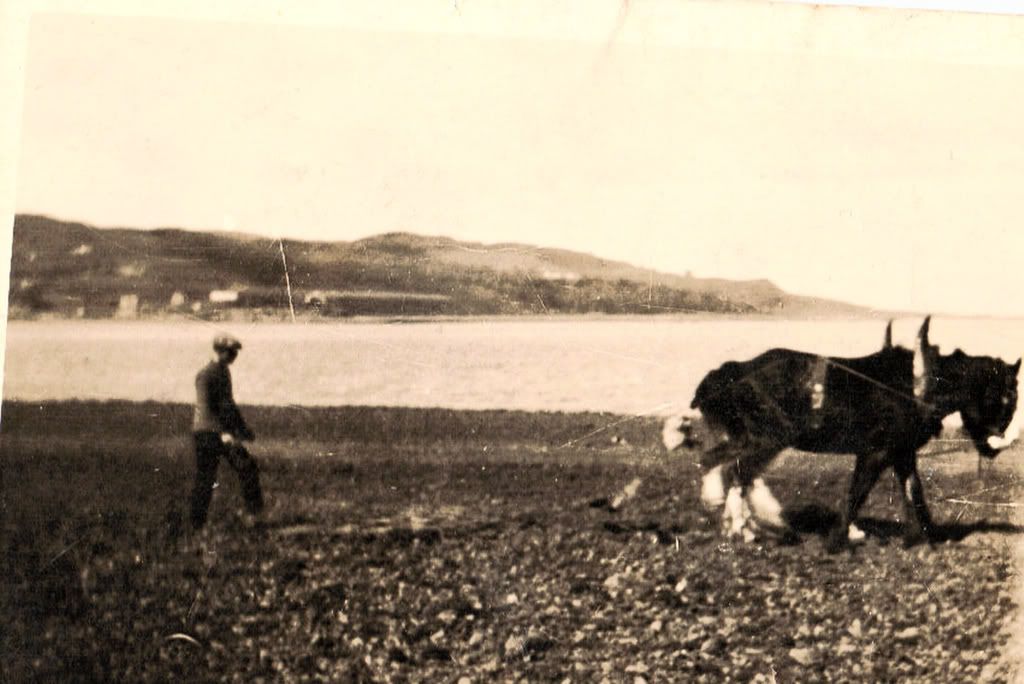
found this last night, thought it should be shared, might interest some, don't know who it is or wether theres any family connection
- general jack o'niell
![]() by spangles » Mon Mar 03, 2008 5:41 pm
by spangles » Mon Mar 03, 2008 5:41 pm
Looks like a shot taken from Andy's farm down at Kilkerran Park. That looks like the Maidens Plantain to the right and the shipyard buildings straight across with the large house that was latterly the Shipyard office and to the left it looks like the old Fairyflower house that was extensively damaged during the war. Fleming the old Chemist's house is now on that site.
Could be wrong but it's very like what I have described.
S
Could be wrong but it's very like what I have described.
S
- spangles
![]() by Roading Boy » Mon Mar 03, 2008 9:53 pm
by Roading Boy » Mon Mar 03, 2008 9:53 pm
is it on route to the Island - so I say its on the Dhorlin 
- Roading Boy
- Active Poster

- Posts: 280
- Joined: Sun Oct 01, 2006 10:53 pm
![]() by ionnsaigh » Tue Mar 04, 2008 8:02 am
by ionnsaigh » Tue Mar 04, 2008 8:02 am
I think it may be the area just before the crossing - or opposite the goldsmith - or is that spot at a greater elevation?. It looks near the wee burn.
O'Donnchadha
-

ionnsaigh - Forum Addict

- Posts: 3714
- Joined: Thu Aug 03, 2006 8:31 am
- Location: The Dear Green Place

![]() by general jack o'niell » Wed Mar 05, 2008 10:39 am
by general jack o'niell » Wed Mar 05, 2008 10:39 am
sorry, i didn't realise anybody actually expected me to come back and tell you, i thought everyone would know where it was,taking into account the angle of the camera and the age of the picture which would not have had the modern zoom lens capability, would suggest that it is the strip of land on the seaside of the road after the graveyard. younger viewers won't remember that parcel of ground before it had houses on it. how many are there? five or six? its not possible to see the little burn that divides that bit of land from the triangular section where houses have been more recently built, so it could be either side of the burn. i've no information about when the picture was taken but the old sheds of the former shipyard are visible so i reckon it was taken after the turn of the last century, maybe pre WWI, 1912 comes to mind as a date having some connection with the old yard, tho what i don't remember, just remember reading something somewhere, theres plenty know the history of that far better than me. i'll show it to angus when he delivers my post today, see if he can shed any light on it.
- general jack o'niell
17 posts
• Page 1 of 2 • 1, 2
Return to Photos from around Kintyre
Who is online
Users browsing this forum: No registered users and 11 guests
Powered by phpBB © 2000, 2002, 2005, 2007 phpBB Group
Arrow Theme By Echo -=Designs By Echo=- © 2007 Echo